All posts by celeste

Table Mountain in the snow

It was 2nd July 2014, cold miserable generally in the Western Cape but a massive cold front was approaching, promising snow on Table Mountain on Saturday, 5 July. Now snow in Europe or North America is not an unusual thing, but snow anywhere near Cape Town is a bit of a novelty, as Capetonians will testify. And snow on our beloved Table Mountain is certainly going to have some entertainment value. During the winter months I watch a website that reflects the snow possibility for 1086M, exactly the height of Table Mountain. When the freezing point dips below that altitude, you can be reasonably sure that you will find snow on the summit. The peak of the storm and the lowest indicated temperature was forecast to arrive at midday on that Saturday, so the plan would be to arrive at the summit at that time.

I called some outdoor friends and quickly rallied a small group that were keen to take up the challenge.  Included in our group of ten would be my son Peter, 13 and my friend Ian with his son Leo, 9 years old. We had a few days to prepare, all making sure we had enough layers of clothing and suitable waterproofing etc. You probably know this, but the correct way to dress for freezing conditions is in layers. The innermost layer is to be a self wicking nylon/synthetic fabric. Cotton absorbs your sweat and will keep a layer of cold, non drying moisture around you, basically stealing your body heat. So we shared the knowledge with the kids since this was to be their first hike into snow.

We took beanies, gloves, windbreakers, waterproofs, hiking boots, space blankets and so on.  Some of us even taped plastic bags over our boots to keep the wetness from penetrating for as long as possible. We strted out at the lower cable station and then turned left at the Contour Path towards our chosen route up, being Platteklip Gorge, the shortest and most direct route to the top. But to be sure we would see snow we bargained on hiking all the way across the Eastern Table to Maclears Beacon, the highest point. The cable car was obviously closed with the high winds, so the hike would be in both directions. The hike up was pretty uneventful, the temperatures in the six degrees to eight degrees range at the road, dropping quickly as we ascended. As we got closer to the summit we started noticing people coming down  but not one reported seeing any sign of snow. However, it was not yet midday, so we pressed on, ever hopeful.

As we arrived at the top of Platteklip Gorge the wind increased and the apparent temperature dropped remarkably… wind chill factor. We headed East on the exposed plateau, the wind now hard on our backs and visibility less than 50 meters. Every now and then the incoming cloud seemed to clear for a few seconds and we could look back towards the upper cable station and see more clouds coming in. But the next wave of cloud looked promising. As we got near the halfway point to Maclears, the wind seemed to drop a little, the temperature certainly fell and suddenly there was snow falling. I remember thinking that I should take some photos but my hands were already cold in spite of my thick leather gloves and I decided to postpone that thought. The snow kept coming and we pressed on. At Maclear’s Beacon one of the party insisted on making coffee on the gas burner he had carried all the way up, so we were delayed there for a few minutes. That gave us the photo opportunity we were waiting for but also very cold hands!  We snapped away pictures for the memories and started the 2km trek back to Platteklip. Incredibly, on the way back we came across a man walking towards us inquiring whether he was headed the right way to find the upper cable station! NOT.  Imagine getting lost in snowy conditions, alone, on top of a windy mountain!

All in all it was a great day out, six hours return trip and a total walking distance of 12 km.

Visit www.tablemountainhiker.co.za 

How fit will I need to be?

Table Mountain looks imposing and there appears to be no visible pathway to the top. The truth is there are a number of clear pathways up the mountain, some easier than others. Most will require zero upper body strength. Table Mountain is not a particularly big challenge and very few people that have joined us on a guided hike have opted out and not completed because of their fitness level. The truth is that unfit people just take longer to finish and we help to select a pace that is comfortable. At the other end of the scale are the people that believe they are fit because they can walk at a strong pace over long distances on flat ground, maybe for two hours or more. But two hours hiking uphill on Table Mountain is a different ballgame from walking on flat ground. And Platteklip Gorge, which is the shortest and most direct route to the top, has about eight hundred double height steps and the muscles and effort required differs from climbing ordinary stairs and is very far from flat ground walking.

Although every route up Table Mountain is steep and stepped, we know that the slightly longer routes are much more interesting, and hikers doing these more exciting routes find they are distracted by the beauty, cliff faces and stunning views, all working together to get the summit under your feet in an apparently shorter time.
Provided you have had a good breakfast, drink plenty of water and hike on a ‘normal weather’ day, you should get to the top without too much strain. However, if you are a total couch potato, we suggest you do Lion’s Head first as a tester and then progress to Table Mountain once you have conquered that little peak.

Here’s a rule of thumb test. If you can do any one of the following 3 things, you should manage Table Mountain without too much effort…
• Jog 5 km without stopping
• Climb 15 flights of stairs (slowly), but without stopping
• Cycle 25 km non stop, in a respectable time
If you would like to discuss a hike or want advice of any sort, please feel free to call Dave directly on + 27 (0) 837888888

There’s nobody on the Mountain!

A doctor from Johannesburg booked a hike with us recently, made the booking about two weeks in advance. We started corresponding about the hike via Whatsapp. David had last done the hike when he was six years old and it had made such an impression that he wanted to do it once again. His friend Nicole would be joining us too. The hike was scheduled for a Tuesday and from the Friday before I was watching the weather closely and feeding the updates. WindGuru. A pile of rain was predicted for the Tuesday morning but was due to clear rather sharply at 2pm. From the Friday to Tuesday morning the weather prediction did not change at all. David’s flight was due to land at 1pm, then he would go directly to the mountain from Cape Town International Airport!

Well, the weather prediction was correct, it rained incessantly all morning and, in my humble opinion, it was unlikely to clear at 2pm. But I headed in the direction of Table Mountain to meet up as arranged, all my foul weather gear with me. And, true as Bob, the weather began clearing right on cue. However, the cable station was still closed due to the strong Westerly winds so we resigned ourselves to the fact that we would be hiking up and then down as well. So we set off on India Venster, on time, as planned. On that route it is not unusual to be the only hikers, in my experience that would be the case about half the time.  David and Nicole are cyclists and runners so there was no problem with fitness. In spite of stopping for photos and snacks, visiting the actual window and generally having a good time, we got to the summit in about two hours. We headed straight to the crack at the top of Platteklip Gorge, glad to be out of the wind. At Platteklip we expected to bump into other hikers, Platteklip being such a popular route. But incredibly there was not one hiker to be be seen which is very unusual. We started hiking down, the huge imposing cliffs on either side of us were almost echoing the silence and solitude. Within fifty paces it was totally wind free and silent… such a contrast from the norm, being so alone in this piece of nature that would otherwise sound and feel like you were jostling for the till point at your local shopping centre!

So we hiked down in about 50 minutes, taking more pictures and video on the way down.  It was a most awesome experience, and one for the record books. You can see a two minute video of the hike  here.

The moral of the story? If you want the mountain to yourself, watch WindGuru closely, look for a sharp change in the weather and then get out there! What a memorable hike!

www.tablemountainhiker.co.za 

He got lost on Table Mountain

I have hiked Table Mountain for more than 30 years and I have seen some rather strange things.  One rather hot afternoon in February this year I was hiking India Venster alone, and being a particularly hot afternoon there was not a soul to be seen on the trail. I stopped to have a sip of water after crossing the amphitheater, just before the first scramble. I was sure there was nobody on the route, I had been keeping an eye out from the halfway point, from where you would see anyone approaching from a long way off. I was resting, appreciating the view of the city when I suddenly became aware of movement coming towards me hurriedly on my left hand side. I quickly established that the somewhat frenzied approach was not a threat to my safety but rather a plea for assistance. It turns out, this hiker had gotten himself pretty lost and into difficulties, had seen me at the halfway point and rushed and scrambled his way across the ‘Skywalk’ to reach me.

So here’s the story. It turns out he is Benson, from Zimbabwe,  and he works as a waiter at a well known restaurant in Long street. He had arrived on Tafelberg Road around 9.00 am, completely unprepared for what lay ahead. He had no hiking kit with him at all just a mobile phone. From what I was able to establish, he started at Platteklip Gorge where he had his last sip of water from the stream, then turned right at the contour path. He told me that he found a path that went up the mountain past a cave on his right (Union Cave?) and then likely to Yellowstone Ravine. In putting together the pieces I believe he went up Union Ravine and eventually lost the pathway, which admittedly can be unclear at times. He then did the best to climb upwards and towards the cable car lines which he could see in the distance. He says he climbed up a steep scramble which he thought would lead him to a clear pathway for some reason but eventually found himself on a narrow ledge with his back to the mountain and no easy way down. He was too scared to jump from the ledge he had wriggled onto and also became scared of slipping off. He had no option but to stay where he was and wait for help, all the time terrified that he would slip off the ledge and be seriously injured if he even tried to move. After about two hours it dawned on him that help was not going to be walking past anytime soon and he decided to call emergency services for help. He called 10111 from his cellphone, which was already running low on power. While he did manage to let the police know he was in trouble on Table Mountain he was unable to describe to the police where he was at all. This was his first time on the mountain and he could not name one of the routes he had used. When the battery died and help was still not arriving he decided to climb down in spite of the risk. He says he threw his shoes down to the level below him and with bare feet he did manage to get himself off that ledge safely. In my opinion, at this point he should have called it a day. But onward and upwards he went, finally crossing Africa Ravine, hot, sweaty, no water, no sunhat, no mobile phone, no map, no laces, no clue!

To his credit, by pressing on in a general westward direction he eventually saw me moving leisurely up the amphitheater and did a bundu bashing crossing to intercept me. By this point he had already been in the blazing sun for 6 hours and was very grateful for my spare 750ml water which he gulped down in record time. Once I had established that he was in reasonable shape in spite of his ordeal, I pointed the way down. He was having none of that! No, he wanted to complete the hike and would I please lead the way! Ok, we spent a few minutes there and I got the full story out of him. He had called the police and I know they would have passed the rescue effort on to Mountain Rescue. I called Mountain Rescue directly and after confirming his identity they were able to cancel the search party which was already mobilised on the mountain. I was asked to give them a confirmation call when we arrived at the top, which we did. The moral of the story? Always carry much more water than you yourself will need, lost hikers can get really thirsty!

www.tablemountainhiker.co.za

Blister bush on Table Mountain

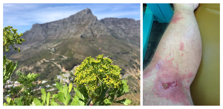
Table Mountain is a great place for hiking and solitude. Besides the obvious dangers like steep cliffs, snakes, getting lost, dramatic and swift changes in the weather etc, there is another lurking danger that can spoil your day! The Blister Bush, or Notobubon galbanum . This plant will keep you awake and scratching incessantly for a week (according to my friend Justin, see photos of his legs) after he had the misfortune of coming into direct contact with the plant. The interesting thing is that the group leader was unaffected by the plant, although he too was wearing shorts on that hike. This is because the first person to brush against the bush damages the leaves or stem so the people following behind the leader are more likely to be exposed to the weeping plant AFTER the damage was done by the first hiker. So the followers are likely to get some of the juices on their bodies and it is the juice that does the damage.
It is understood that the juices break down whatever it is in the human skin that naturally works to prevents sunburn

The leaves of the Blister Bush’s look like flat-leaved parsley or celery with signature jagged edges on each leaf. The plant is evergreen and has a yellow flower, about the size of a tennis ball, perhaps resembling a miniature firework with tiny yellow flower on the end of each of about fifty stems of roughly equal size. The bush can grow a bit taller than a human, perhaps 2.5 meters tall. On Table Mountain they appear far more near the top of the mountain, from say the height of Fountain Ledge upwards, but they can be seen slightly lower down too. They enjoy partly shady and damp areas more, but have also been spotted in areas of full sunshine as well. On India Venster route they can be found as low down as the staples and even Platteklip Gorge has it’s fair share of them too, right alongside the path. (It would be so interesting to know how many people come out in blisters and sores each week, I wish there was a way to find out!)

If you know that you have brushed up against the bush, wash the area with water immediately. Also apply the highest factor sunscreen and if possible keep the affected area out of sunlight for two or three days.
If you have spray on type of sunscreen, particularly if high in alcohol, it will help dry the welt and reduce the irritation with immediate effect. If sun tan lotion is applied soon enough, the process can be interrupted in its entirety. If you were too late to apply suntan lotion and if the sore is left untreated the welt may stop itching and weeping after about five or six miserable days. Once the itching has stopped then leave it exposed to allow the affected area to breathe. Depending on how badly the area was affected, the scarring can take many months to disappear altogether.

Prevention is first prize, so take a look at the photos of the blister bush and next time you are out hiking, try hunt one down and become familiar with it (from a distance!) Then point them out whenever you hike with friends.

themountainman

www.tablemountainhiker.co.za